Sunday, December 11, 2011

Coolgardie and Kalgoorlie


The water pipeline to Kalgoorlie from Perth was conceived in the late 1890’s following the discovery of gold in Coolgardie in 1892 and the influx of people into the area all hoping to discover their fortune.  As the supply of water for the new goldfield was nearly as expensive as the gold they were searching for as it was carted by camels nearly 400km.  The first gold was discovered in Coolgardie by two gentlemen and just 4 years later one of them was to die aged just 31.  Patrick (Paddy) Hannan’s discovery in Kalgoorlie was not made till 1896 (after the decision to build the pipeline).  This pipeline would carry water over 600km from Mundaring Weir in Perth to a reservoir on Mt Charlotte (part of the Golden Mile) in Kalgoorlie.  This involved the use of 8 pumping stations, originally steam powered and now electronically controlled from Perth.  The engineering feat was completed in 1902 and the pipe was built of steel with the various pipes joined by lead.  The pipe was buried underground in order to help prevent heating of the water and possible evaporation.  During the Depression years the unemployed were used to dig up the pipeline, carry out repairs and place the pipeline above ground for the full distance.  It was found that the salinity of the ground had caused corrosion on the outside of the pipe so that led to the decision for the pipeline to be raised.  It is now painted with heat reflecting paint to help prevent the temperature rising to high.  The water takes from 2 to 3 weeks to complete its journey from Perth to Kalgoorlie.
the old gaol and Wardens Office at Coolgardie


We stopped and enjoyed a walk up and down the main street of Coolgardie, now often thought of as a ‘ghost’ town but with a determined Shire hoping to entice more tourists to call in.  The gold here was not as plentiful as Kalgoorlie and the population of nearly 25,000 over some decades dwindled to just 200.  There is approx. 1,200 in the shire now and there was a free sausage sizzle happening outside the supermarket on Saturday and members of the Shire were conducting a survey asking locals and visitors alike what was good and what could be improved in the area so in exchange for a sausage sanger we were pleased to give some feedback.  There are some lovely old buildings along the street however some of them do need some TLC and of course that is a question of money so we wish them well with their future endeavours.

any one for an 'operation'?
this is on display at the Medical and Pharmacy display in Coolgardie


Kalgoorlie is full of lovely old buildings.  We walked along the street today (Sunday) and soaked up some of the history just standing there in all its glory.  

  The original Post Office and Wardens Office is being restored and is fenced off but the beautiful stonework can be seen from the footpath.  The clock spire has a golden top and can be clearly seen when looking at a view of the city from any high point.  The land is mainly flat so the lookout at Mt Charlotte (at the end of town) helps give an overview. 
view from Mt Charlotte

We also visited the Super Pit Lookout (no blasting today) and stood amazed at the view of this ‘living’ gold mine. 

 I was amazed to learn that this venture came about through the intervention of Alan Bond back in the early 1980’s.  This area known as The Golden Mile, had various mining leases held by different people.  Alan Bond saw that if these leases could be combined the area could be mined more efficiently and more gold recovered.  He went about buying up these leases but when his financial crisis arose the development of this venture was taken over by others and thus the Super Pit was born.  The area to be mined in total is 3.6km long, 1.35km wide and to a depth of approx. 600 metres.  The Visitors Centre is informed each day if there is to be a ‘blast’ carried out so we will be checking again tomorrow in case there is. 

We were disappointed to see that the old railway ‘loop’ line we rode when we were here in 1996 is now no more, just a museum.  It is possible that the Super Pit has absorbed part of the area the historic railway line ran through.

Patrick (Paddy) Hannan

Friday, December 9, 2011

Kalgarin towards Coolgardie

farmers with a sense of humour involving hay bales
there were about 8 in total in the paddock

Well the water gods were smiling this morning and we were informed that the road through to Kondinin was open so off we go.  During our stay at Kalgarin we met up with another couple from Bridgetown (Stan and Miriam) who had been held up for four nights waiting for the water to subside.  They had been at Kalgarin the night of the storm and said it was fairly spectacular with thunder and lightning, never mind the rain.  They too are travelling to Kalgoorlie before turning south back towards their home.  So now we have us a ‘convoy’ (of two).  We drove through a few lots of water over the road on our way to Kondinin but nothing too deep.  When we arrived at Kondinin here is a road block set up stopping traffic from travelling the way we had just come.  We asked what was going on and was informed that the road (we had just travelled) was closed!!  Well seems as though there is a variance in information, just depends which Shire you talk to.  We let the nice people at the roadblock know that the road had been no problem however, guess they have to wait for someone higher up to let them know that as the roadblock continued. 
approaching Narembeen

Heading on then to Narembeen (about 50km), we arrive at the outskirts and well here is water over the road and this looks much more impressive, but no signs, no roadblocks, no anything! 
edge of Narembeen

Very cautiously we proceed through the water, probably up to the hubs of our wheels and safely out the other side where we could then pull off the road for a rather impressive sight of the water coming under the railway line and into the channel. 


We made our cuppa and one after the other of locals arrived to take photos, discuss the last time it had been like this, do you remember when etc.  Was very interesting for us to watch other vehicles come through the water and have a local give us a running commentary on who they were and what they might be doing.  A grader was despatched to travel 4km down the channel to then create more channels so that the water would not continue to spread as wide as it was.  It is hoped that this would prevent ‘widespread’ flooding.  Our guide informed us that he had property worked by his son 90km east of Narembeen and there had been 125mm (5 inches) of rain there on Monday night and that water still has to arrive in Narembeen so the flooding will continue for a while yet.  The culvert under the railway line was creating an impressive ‘weir’ look and the sand bank beside the line was starting to break away so who knows what will eventuate with the water pressure continuing for some time yet.

                  water under the railway line at Narembeen

We finally pulled ourselves away and headed for Merredin and the Great Eastern Highway, needless to say the road for all points East.  We enjoyed lunch in Merredin, afternoon tea in Southern Cross and then finally on to our free campsite about 120km from Coolgardie.  Our Kalgarin friends also pulled in for the night and we enjoyed a chat and walk back through the bush after dinner and photos of the beautiful sunset.  Tomorrow, on to Coolgardie and Kalgoorlie where we will stay for a few days.
sunset at our camp site

Pipe carrying water from Perth to Kalgoorlie


Hyden and Wave Rock

The turn off to Wave Rock came up before heading into town so we drove the 3km out to the parking area and caravan park situated at the rock.  Photos of the area we had previously seen only showed ‘the wave’ however this is actually only a small part of Hyden Rock which covers over 3.6 hectares. 
Wave Rock - just a part of Hyden Rock

The rock is granite and there are various walking trails well set out and marked to follow.  We paid our $7 day fee (to the local Shire) and set off to take a wander.   Wandering along the path to Hippo’s Yawn we could still see water trickling down the sides of the rock and also along the path there were areas that had obviously been washed away by the gushing water. 
Hippo's Yawn at Hyden Rock

water running down the rock

We were able to admire the bottlebrushes flowering amongst the She-oak trees around the bottom of the rock as we walked the trail.  After reaching Hippo’s Yawn we then retraced our steps to an area where it is possible to easily walk up onto the rock.  There were holes on top filled with water and also mosses and lichens growing thickly up there. 
water with lichen and moss on top of the rock

view from top of Hyden Rock - lake in distance

 The view across the nearby countryside showed lakes full with water, or maybe flooded land, who knows?  Was certainly a different experience to a couple of weeks ago when we had been in the area of bush-fires.  The diversity of our wonderful country never ceases to amaze.  

When this area was settled in the 1920’s Hyden Rock was considered a natural catchment for water and a dam was built at one end for storage.  A ‘fence’ was built around part of the top of the rock so as to help channel the water for collection.  This catchment area was expanded in 1951 and increased the storage 10 fold and today we could see that the dam was completely full. 
wall on top to channel water to the dam

Hyden dam full to capacity

The short drive into town again showed us water beside the road and when we turned into the service station to fill up with gas we could see that the water had been across the road there not so long ago.  Asking the local lass inside she informed us that the water had fallen in the last couple of hours and it had not been this wet for 8 yrs.  We also found out that our intended road was actually closed due to flooding so we could travel on another 16 km but that was the end of the line for the present.  We travelled again through 2 more lots of water and then set up in the van park to wait it out.  Hopefully overnight the water levels will fall and we will be able to travel on even if along a different road.

Pemberton to Hyden

Leaving Pemberton we backtracked through Manjimup to Bridgetown before then turning off towards Boyup Brook, Kojanup and our next over-night at Katanning.  We have certainly left the tall timbers behind and are now heading back into the wheat country.  Harvest is underway and the weather has taken a nasty turn for them.  There were heavy rain falls overnight through part of the wheat-belt and those still harvesting will not be too happy.  We also are not too happy as the left wheel on Destiny is again getting hot.  What could it possibly be now?  The biggest problem is that it runs fine for a 100km or so and then after having a coffee break (us that is) it wants to again get too hot to touch and start ‘squealing’.  Lawrie visited another ‘brake’ mechanic in Katanning and he did some more fiddling and again all seemed fine.  Next day we headed off to Lake Grace (151km), stopped for gas and the wheel was fine, travelled on towards Lake King and after 80km here was the squealing and heat again.  So frustrating.  We stopped off the road and ‘had a cuppa’, Lawrie then jacked it up to check everything again and a local farmer stopped to offer help.  Seemed the local ‘super’ mechanic at Lake King (another 30km and our destination for the day) is Tonk’s uncle so he rings and advises that we are on our way so that he would wait to see us.  Tonks advised us that he was farming 16,000 acres, has a mixture of wheat and wool and that there had been 100mm (4 inches) of rain the other night and he had been in the middle of harvest.  Seems now that the grain will only be suitable for stock feed (much lower value) instead of good quality grain at a much higher price however as he said, that’s the way it goes on the land.  We enjoyed the chat and learnt a lot about what is going on locally, how it is difficult to get workers as everyone heads for the mines with high wages on offer, and that once the children reach high school age they need to leave home to attend boarding school.  Chats like this help to put ‘living on the land’ into perspective.  Vic was waiting for us when we arrived and after checking though his thoughts of what might cause the problem they agreed it as a ‘mystery.’  They settled for repacking the bearings on the left wheel and ‘see how that goes mate’.   
the 'pink' of a salt lake

It was already dark once we left the workshop and checked into the local van park.  Fortunately dinner had been cooked the previous day so I only had to ‘reheat’ which was a blessing.  Driving into Lake King we had crossed a 10km causeway across salt lakes studded with natural scrub and still some wildflowers peeping out.  The area is a productive farming community that was once part of a land settlement scheme in the 1920’s involving 3,400 farms.  Unfortunately the Great Depression came along in the 1930’s which meant the promised railway line did not eventuate thus families found farming out here and fighting the salinity of the land too hard and there are now only a few of those original farming families still in the area.  Wheat silos can be found in the village along with a tavern and a service station, a couple of machinery connected businesses and a few houses. 
water on the way to Lake King

Following the storm of Monday night we had seen water lying in paddocks, beside the road and dams that were over-flowing and flooded roads as we had approached Lake King.  It was surprising how fast the water was running in sections and caution certainly was the name of the game.   Leaving Lake King next morning (Thurs) it wasn’t long before we again were driving through water across the road as we headed towards Hyden and the famous Wave Rock.  Nearly half wheel depth in places and still flowing quite fast. 
looking out my window as we drove through

Monday, December 5, 2011

the trip to Windy Harbour and the Berry pancake adventure

The weekend became quite warm and we spent the time doing the housework and washing etc.  Monday found us doing our last ‘tourist’ things here in timber country.  We did the drive down to the coast at Windy Harbour.  The name is self-explanatory and is very true.  The day was warm and sunny and the water sparkled and the wind blew! 
Windy Harbour and the coastline

Windy Harbour is just a small settlement, no electricity just a generator supplies the power for the little houses that shelter behind the dunes that line the coastline.  There is a fishing fleet based here but we noticed today that they were all moored in the bay as I guess the water was too rough for fishing. 
Turning about we then headed back towards Northcliffe and called into the Info Centre and then drove their Forest Park trail.  This is only short but provides some picnic venues and there is also a couple of walking trails that lead off. 
twin Karri at Northcliffe

We did the Twin Karri Loop walk and enjoyed again walking through the mighty forest.  The twin karris soared upward and certainly looked unusual.  Back at our parking bay we explored the Hollow Butt Karri tree which was discovered in 1981 and was the inspiration for the development of this forest reserve adjacent to the town which could be used for the enjoyment and education of locals and visitors alike.  Just think, what must the total girth of this tree have been before it started to hollow out and therefore how old must it be?
Hollow Butt Karri tree at Northcliffe

On returning to Pemberton we treated ourselves to lunch at the Lavender and Berry Farm.  We had read and heard about the berry pancake offered out there so of course had to try it and thought we would keep the best till last. 
Lavender and Berry Farm gardens

Well they have large and small so naturally being hungry Lawrie opted for the large and myself for the small.  He had maple syrup and ice-cream and I had the hot berry sauce with ice-cream and well the taste was incredible. 
our lunch and the 'small' is at the front
Large was certainly large (as in large dinner plate size) and along with coffee he was pushing to finish.   Yumm oh!!  You are able to walk around the lavender and rose gardens, pet the miniature horses, feed the alpacas or sheep, check out the chooks and marvel at the beautiful Splendour Blue Wren that lives there and even visits the seating area and looks for crumbs etc.  What a magic little bird.
Splendour Blue Fairy Wren

As mentioned earlier, our time here in the tall timber country has been really special and we have thoroughly fallen in love with this area but journey on we must as there are still many places to go and lots to see.
Port Lincoln Parrot

Day trip along the Karri Forest Trail

Friday we packed a picnic lunch and ventured out for the 86km Karri Forest Explorer Trail which winds through some of the south-west’s most magnificent karri forest.   Heading out of town we first visited the Gloucester Tree which is 60m high and was chosen for a fire lookout in 1947.  There was a network of lookouts built in the karri forest between 1937 and 1952.  This is one of only 3 still in operation and the general public can climb the tree (be it at their own risk)!  I had thought I would like to do that however once seeing the tree and realising the pressure that would happen to my right hip with all those ‘up’ steps, I thought better of it and decided to scrap it off my list.  I am sure the view from the top would be pretty spectacular however.
Gloucester Tree Lookout

climbing the Gloucester Tree (60m in total)

We enjoyed lunch at the Big Brook Dam, built to supplement the water supply for Pemberton and the local trout hatchery in 1986.  You can swim and fish in the dam and there is a sandy beach with lots of picnic areas set up (but the water was cold)!   We drove along the various tracks that make up the trail (it was very well signposted) and part of the track is one way so the dirt track was quite narrow and in some places steep as you descended to the Warren River running nearby.  One of the stops along the trail was called ‘Giblett’ where in 1987 protesters took to the trees to prevent the logging of the old growth forest.   In 2005 the area was declared a National Park and the beautiful trees are now protected.  There is an interesting display at Giblett telling the story of the successful protest that lasted for many months through the winter.

Another stopping point along the trail was Beedelup Falls in the National Park. 
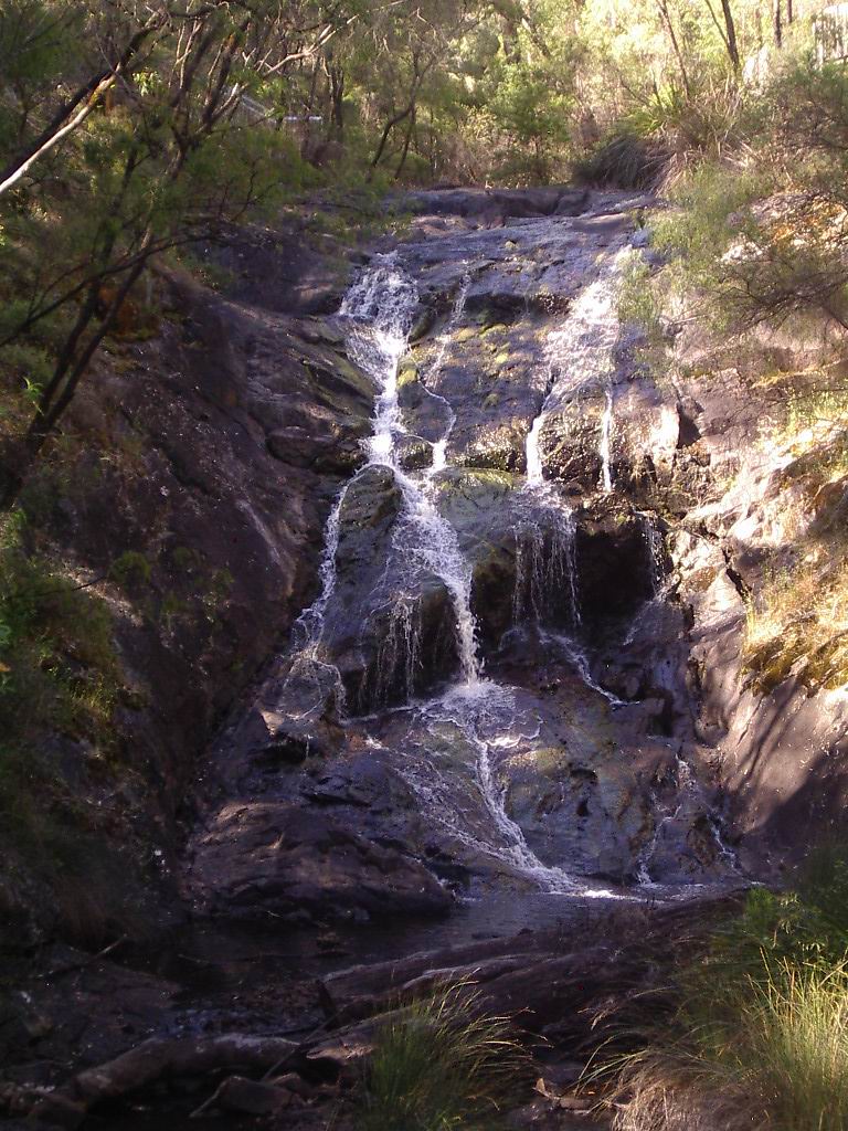
Beedelup Falls
During winter this area has quite good rainfalls and you can only imagine what the falls would look like after heavy rain.  The falls drop for 100m over a series of steep granite rocks.  We ‘enjoyed’ walking the swing bridge across the falls (good photo opportunity) but it sure moved around a bit.  Left you feeling as though you were still moving once you were walking on solid ground the other side, quite strange. 
Leaving here we then drove on to where the trail took us down to the Warren River along a section known as Heartbreak Trail.  
the Warren River
This steep track was built by hand to clear a path down to the river for the fire fighters, its name reflecting the hardship of the job.  The trail then follows the river a ways with campsites and a lookout along the way.  This national park (Warren) has virgin karri forest along the valley of the river and contains another ‘climbing’ lookout tree, the Dave Evans Bicentennial Tree (91m high) which was pegged in 1988.  From here it is only about 15min and we are back in Pemberton.  What a great day it was and we were sure pooped after all the in and out of the car we had done at the various stops.

Pemberton Western Australia

Well we have had our week and actually leave here tomorrow.  Where has that time gone?  However it has been truly marvellous.  Our first adventure was on the Pemberton Tram ride into the forest. 

 This diesel motor tram carriage ventures into the forest along old railway lines that were used by the mills in days gone by but ceased to run in the 1980’s.  The tram crosses 6 bridges, stops at the Cascades and at the Warren River Bridge before returning to Pemberton.  When leaving Pemberton you pass the working saw mill and then descend into the Karri forest where you pass Karri, Marri and Jarrah trees reaching to the heavens. 
setting the railway boom gates to lower

passing the working saw mill

travelling through the forest

the Warren River Bridge


the Cascades

looking down from the rail into Lefroy Brook

West Australian Karri is the second tallest tree in the world (reaching 90 metres) after the mighty Californian Coast (America) Redwood which reaches 100m and third tallest is the Victorian Mountain Ash.  The Karri, whitish grey in colour after shedding its bark, grows at approx. 1m per year in height, tall and straight until reaching its peak and only then does it start to thicken out.  One can only wonder at the age of some of the trees we have seen that would need at least 4-6 people with arms outstretched to circle the trunk.  They only have branches at the top of the tree so the trunks look like telegraph poles. 
Bruiser in the Karri forest

The Marri (known in the east at Bloodwood) is not as tall and has rough bark that seeps red coloured sap (therefore ‘bloodwood) so is quite distinct to the Karri.  The bark is often black in colour and looks as though it has been through a fire.  Jarrah has a trunk that is smooth but ‘striped’ in appearance. 
Marri or Bloodwood weeping sap

The trestle bridges that we crossed look quite daunting from the carriage as they are high above the water of the Lefroy Brook which runs into the Warren River at our last stop.  The trip takes 1 ½ hrs and we would thoroughly recommend it to all.
hedge sculpture at Pemberton Railway Station


Thursday saw us doing a drive into Albany (approx. 450km return) so as to pick up the mail that had been forwarded.  We drove down to Northcliffe before veering off across to the South Western Hway which took us through Walpole, (home of the Tree Top Walk), Denmark and then onto Albany.  We had visited this area twice previously so the aim of the day was to get the mail and then return.  Albany is a thriving busy centre and for tourists there is much to see.  Previously a centre for whaling there is now a whale world museum which is quite interesting to visit along with historical buildings etc.  We enjoyed our lunch after collecting the mail and then headed back out of town.  We returned via Mt Barker and the Muirs Highway through to Manjimup and I even gave Lawrie the afternoon off and drove home from Mt Barker.  We passed through more tall timber country along with lots of grazing cattle so the journey was quite enjoyable (and not much traffic).